Seth Stein, ’78, began his geoscience career as an undergraduate at the Massachusetts Institute of Technology studying moonquakes using data from seismometers deployed by the Apollo missions. The Hertz Foundation checked in with him shortly after the 50th anniversary of the Apollo 11 moon landing to discuss his lunar research and how he spent the rest of his career.
Stein become spellbound at MIT by the revolutionary new geological discoveries in plate tectonics. Inspired by this new understanding of how the Earth works, he focused his graduate studies on earthquakes, plate tectonics, sea-floor spreading, and crustal rifting. These processes have shaped the Earth’s surface for billions of years. Our solid ground only seems relatively unchanging on the scale of a human lifetime. It is, in fact, in constant motion. Stein, the William Deering Professor of Geological Science at Northwestern University, tells us how he and his colleagues have charted this mostly invisible motion.
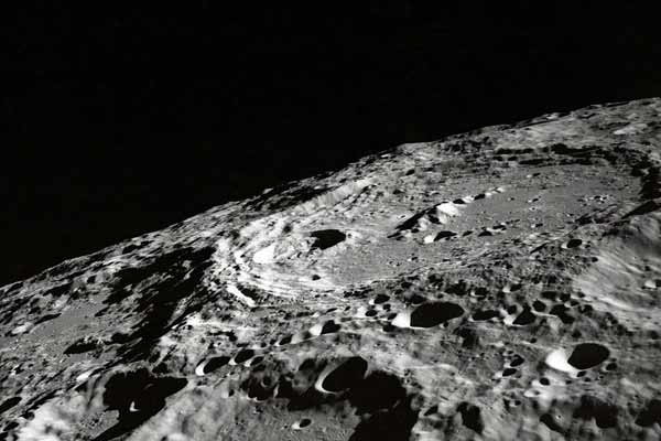
Hertz Foundation: When we relive the excitement of mankind’s first steps on the moon, we sometimes forget the Apollo program had a science component – including conducting a lunar seismic experiment. As an undergraduate, you were among those looking at the data. What did we discover?
Stein: Scientists discovered there were two types of moonquakes. One type occurs relatively deep in the moon and is related to tidal stresses, meaning faults in the moon are being tugged and moved by the Earth’s gravitational pull. The second type happens when meteorites hit the surface – which happens frequently, since the moon lacks atmosphere. These two types generate seismic waves that have different shapes after they travel through rock. Researchers combined their data to map the moon’s interior.
HF: Along with mapping the moon, did we make any discoveries?
Stein: Scientists found the moon looked very much like terrestrial rocks, which was gratifying. The small differences gave new insights into how the moon formed. The Apollo missions also got everyone thinking of what became known as “comparative planetology” – uncovering the similarities and differences in the lifecycles of planets and celestial bodies, particularly in relationship to the Earth. This includes a deeper understanding of how heat is the geological lifeblood of planets. Plate tectonics is key to how the Earth’s heat engine works. We started thinking about other planets in this context.
HF: You said one type of moonquake is caused by the Earth’s tidal stress. Since there is no water on the moon, what actually occurs?
Stein: The solid rock goes up and down, just the way water does. The effect is much smaller, of course. When I was working with the Apollo data, we used the resulting moonquakes as seismic sources to probe deep into the moon. The challenge is that the outer shell of the moon heavily scatters seismic energy, which makes it hard to see reflections off interfaces in the interior. The technology of the time limited what we could do – especially for probing the moon’s core – which remains uncertain.
HF: Since those Apollo days, you’ve focused most of your career on plate tectonics and related phenomena here on Earth.
Stein: Between the discovery of plate tectonics in the 1960s and the Apollo program, geology was the really hot science in the 1970s. I was fortunate. There was a large plate tectonics effort at MIT. Two other things interested me as well. One was planetary science, and the other was how earthquakes work. All these interests overlapped like a Venn diagram and have stayed with me over the years.
HF: You pursued graduate work at the California Institute of Technology on a Hertz Fellowship from 1975 to 1978. Your adviser was Hiroo Kanamori, one of the most influential seismologists of his generation. What did that experience mean to you: having a Hertz Fellowship and being able to work with a scientist who has made seminal contributions to the understanding of earthquake physics and hazard mitigation?
Stein: It was really wonderful. The Fellowship made being in grad school pretty much the same as being a faculty member. I could pick the problems I wanted to work on. I got great advice from Hiroo, now retired from Caltech, who is one of the great people in our business. I try to create this spirit with the graduate students I work with.
HF: One of the high-profile papers you co-wrote as a Caltech graduate student dealt with the surprising amount of earthquake activity you found in the long, straight mountain chains of the Indian Ocean. They were mistakenly called aseismic ridges, meaning that they lacked seismic activity. What were the implications of your discovery for understanding how plate tectonics works in that part of the world?
Stein: Nobody knew much about aseismic ridges. A fellow grad student and I looked into this and we discovered they weren’t aseismic at all. In fact, the activity level was about the same as the San Andreas fault. All the geology books at the time had India and Australia on the same plate, called the Indo-Australian plate. We used the earthquake to show that there’s a lot of motion between what we now know are two different plates. That drew a lot of interest because changing some long-accepted view always draws attention.
HF: In 1990, you led a team that looked at crustal movement in a part of the Midwest that hasn’t experienced a major earthquake in more than 200 years. What got you interested in this?
Stein: The national seismic hazard maps were showing that Memphis, Tennessee, was in greater danger from earthquakes than Los Angeles or San Francisco. This seemed implausible, because Memphis is in a much less seismically active area. Using the then-new GPS technology, we found the ground wasn’t moving, so there’s no sign a big earthquake’s going to happen any time soon. So we questioned experts about how accurate and reliable the earthquake hazard maps are. It turned out that no one knows how well these maps predict future shaking, so we’ve been investigating this.
HF: That project evolved into a collaboration with your late father, Jerome Stein, an economist at Brown University, to help states and the nation better assess the costs and benefits of earthquake preparation.
Stein: Given that we can assess hazards, but not all that well, we’re faced with the question: what should we do? My father and I realized that we still weren’t very well set up to think about the costs and benefits of different hazard mitigation strategies compared to other uses of these funds. Are you better off putting steel in your school buildings or are you better off hiring teachers? If you’re the Memphis school board, how would you allocate your resources between them? So we provided ideas for this.
HF: What’s the bottom line?
Stein: Some intermediate level of mitigation seems to make the most sense. It’s a principle of diminishing returns. The net cost of a natural hazard is the sum of the damage from a natural disaster and the amount of money you spend preparing for it. If we do nothing, we may have lots of damage. But if we spend so much money that we pretty much eliminate any possible damage, the cure would be worse than the disease.
HF: In your more recent work, you, your wife, and colleagues have studied an ancient feature in the Midwest called the Midcontinent Rift. You’ve extensively mapped this mostly buried rift, which begins in Oklahoma, curves like an upside down U to Lake Superior, than turns back down to Alabama. Why does it interest you?
Stein: We’re looking at two long-standing questions: how do continents split and how old is plate tectonics on Earth? This rift, which nearly split North America apart, is at least 1.1 billion years old — roughly a quarter of the age of the Earth. That means plate tectonics was operating 1.1 billion years ago more or less the way we know it today.
HF: What happens when a rift succeeds in splitting a continent?
Stein: If a rift succeeds you get a new ocean, flanked by continents whose edges are like the U.S. East Coast. These are called passive or rifted margins. Most of the rocks are buried under kilometers of sediment. You can image them seismically but you can’t actually see them, whereas if you go up to Lake Superior, someplace like Isle Royale or the Keweenaw Peninsula, you can walk around on those rocks. They’re a frozen snapshot of how continents break up, and we realized that that was an incredible opportunity to really see how this actually happens. We’re comparing them to structures on the coasts of South America, Africa, and other rifted margins. This gives a pretty good handle to how the structures evolved.
HF: You share the Foundation’s commitment to young scientists. You’ve started a fellowship with your wife and some colleagues. You’ve also recently written some American Geophysical Union blog posts providing advice to help young scientists get a leg up. Do you work with potential Hertz Fellows at Northwestern, too?
Stein: A fair number of Northwestern faculty members were Hertz Fellows. We meet with students who are interested in applying for a Hertz Fellowship. We tell them about the Hertz Foundation and help them explain what they know and what they’ve done in their applications. Graduate school is crucial in developing young scientists, because in science we’re the sum of our experiences over all of our years, like any other branch of human endeavor. Hertz was incredibly transformative for me, and I suspect this is true for everybody else. I don’t know of a better system for developing people’s talents.

